
PORTLAND, Ore. — The commission in charge of dividing Portland into four electoral districts for future city council elections has finished the process, unanimously voting to grant final approval to a map after previously narrowing the options down to one finalist candidate map last week.
The map is a key part of the charter reform package that Portland voters approved last November to overhaul the city's form of government. Starting in 2025, the city council will expand to 12 members tasked with setting policy, while administration of the city's bureaus will be turned over to a professional city manager who reports to the mayor.
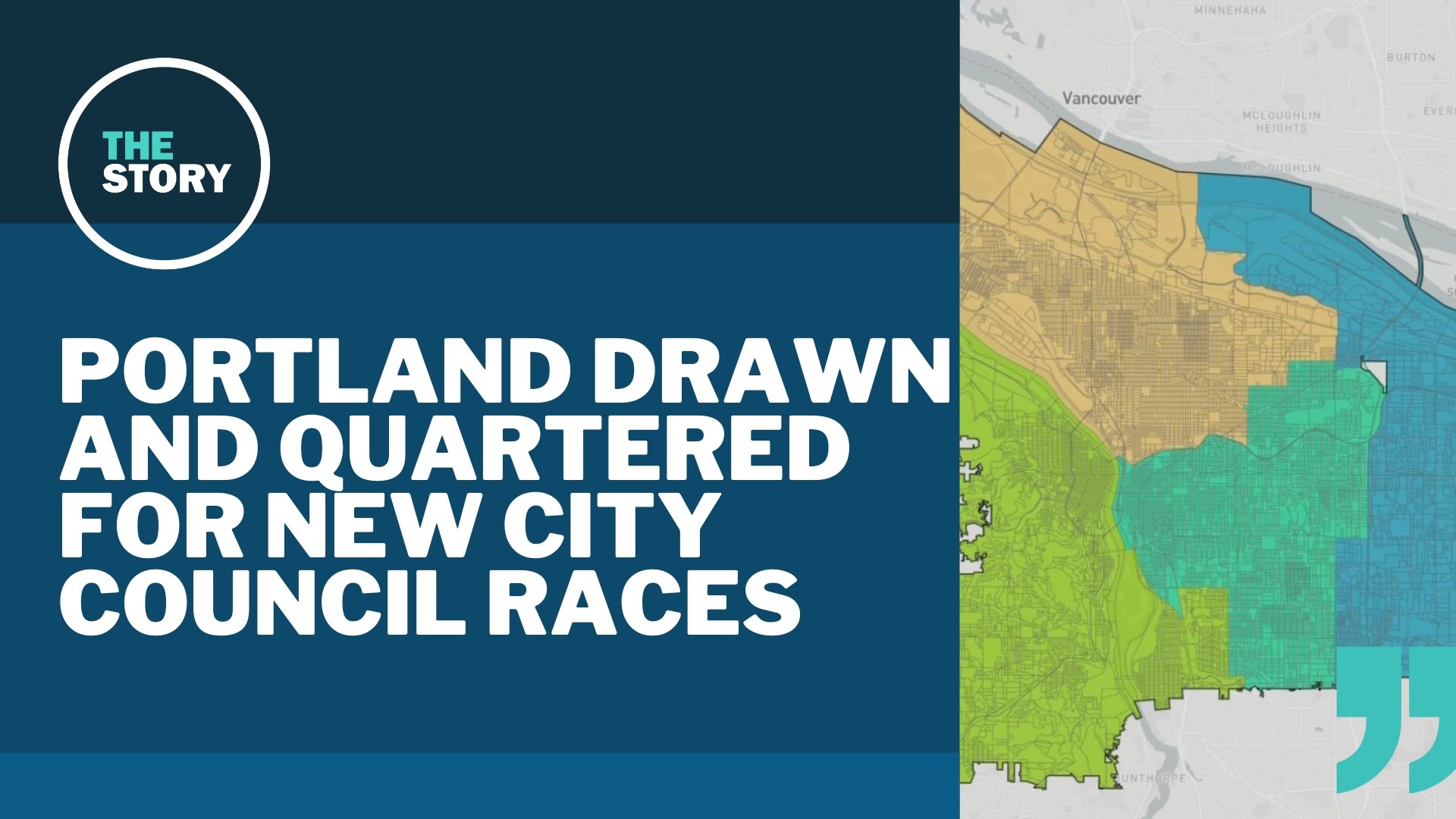
Unlike the citywide races for the current city commissioner positions, the new councilors will be chosen by district, with each of the four districts electing three council members. The map divides the city into four districts of roughly equal population, with the goal of using geographic dividing lines like rivers and freeways as much as possible to avoid splitting up communities.
The city council began standing up the 13-member volunteer commission almost immediately after the November election, and the group spent several months studying various map options and eventually narrowing it down to three final candidate maps, dubbed Alder, Cedar and Maple, which were put forth in early June for public feedback.
The maps were all broadly similar, putting the area west of the Willamette River into one district and the area east of Interstate 205 into another and splitting the remaining middle section of the city into the final two districts, but there were some differences in the exact borders. Alder was drawn to prioritize keeping neighborhoods together, according to the commission, while Cedar prioritized transit corridors and Maple prioritized keeping the central city together.
The final map is a modified version of the Alder map, which the commission said was revised based on public feedback in June and July. The modifications are mostly small border adjustments aimed at keeping communities together; for example, the original Alder map carved off pieces of the Brooklyn and Montavilla neighborhoods, but the revised version keeps them intact.
All of the maps had to make some compromises in order to satisfy the equal population requirement. For example, the area west of the Willamette River doesn't have quite enough population to be a district on its own, so each map put a small part of inner southeast Portland into the west side district. In the final Alder map, that portion consists of the Sellwood-Moreland, Eastmoreland and Reed neighborhoods.
The commission unanimously selected the map at a meeting last Wednesday evening, choosing between the revised Alder map and a revised Maple map. The final approval vote was taken at the commission's Aug. 21 meeting. The districts will be used for the first time in the November 2024 election, where voters will pick the first councilors to sit on the new city council at the start of 2025.